Long Island transport map
You can find on this page the Long Island transport map to print and to download in PDF. The Long Island transportation map presents the transports network and transport zones of the transit of Long Island in New York - USA.
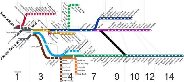
Long Island zone map
The Long Island zone map shows all transport zones in Long Island. This zone map of Long Island will allow you to know the prices of public transport of Long Island in New York - USA. The Long Island zones of transports map is downloadable in PDF, printable and free.
Like Metro-North Railroad and New Jersey Transit, the Long Island Rail Road has a fare system that is based on the distance a passenger travels, as opposed to the New York City Subway which has a flat rate throughout the entire system. The railroad is broken up in to eight numbered fare zones as you can see in Long Island zone map. Zone 1 includes all of the city terminals and stations west of Jamaica. Zone 3 includes Jamaica and all stations east of Jamaica within the boundaries of New York City, except Far Rockaway. Zones 4 and 7 include all the stations in Nassau County and Far Rockaway. Zones 9, 10, 12, and 14 includes all the stations in Suffolk County. Each zone contains many stations, and the same fare applies for travel between any station in the origin zone and any station in the destination zone.